Projects
i-Tree Academy Capstone Project Reports and Files
 Putting i-Tree to Work Today… as a Tool for Science and Engagement
As part of the first i-Tree Online Academy, participants were asked to complete a comprehensive final capstone project that demonstrated their ability to utilize the i-Tree tools to analyze trees in their community, or to engage community residents in examining the greenspace in their city or town. Projects were developed by each student and they were responsible to carry out all aspects of the design, planning and implementation of each program.
The projects and associated resource materials are compiled below, for sharing with the wider i-Tree community. Please take a look at the great work that was completed by our first class of graduates.
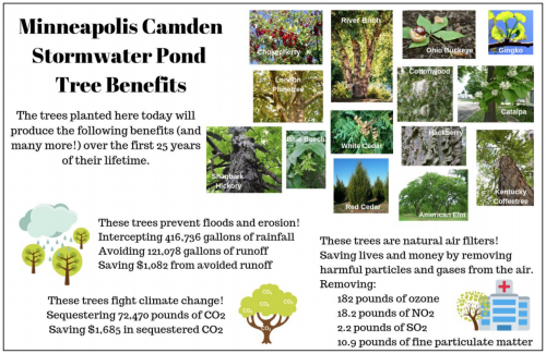
Camden Stormwater Pond Tree Planting Report
by Laura Gold
Project Overview and Resource Materials
i-Tree Planting Calculator Report
On June 1, 2019, 52 trees (primarily #10 containerized stock) were planted by volunteers at the Camden Stormwater Pond in Minneapolis. This planting was made possible through the partnership of The Nature Conservancy, Tree Trust, City of Minneapolis and Minneapolis Park & Recreation Board, with generous funding from United Properties and support from the Webber-Camden Neighborhood Organization, Shingle Creek Watershed Management Commission and Mississippi Watershed Management Organization.
Tree benefits from the planting were calculated using the i-Tree Planting Calculator.
Brunswick Park Woodland Management Application
and i-Tree Eco and Canopy Reports
by Ian McDermott
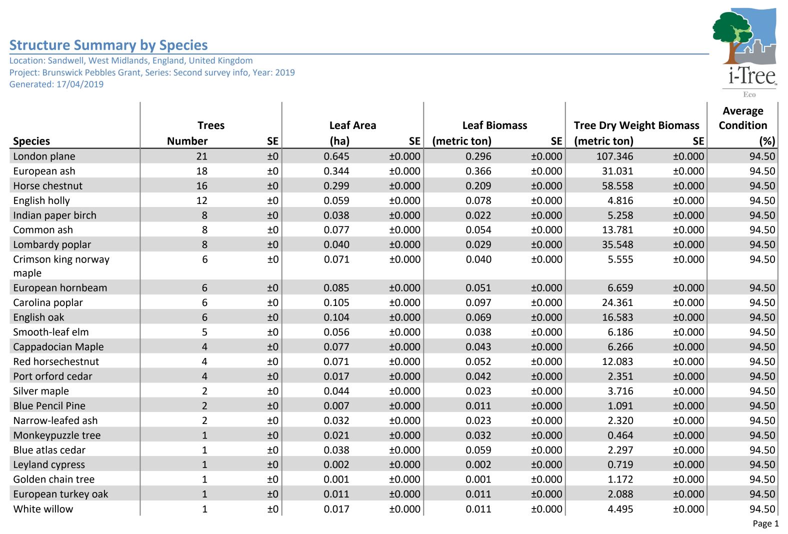
i-Tree Eco: Species Structure Report
Woodland Park Management Grant Application
This project developed an application for a grant to inventory and manage vegetation in Brunswick Park. The proposal was developed by Ian McDermott, in partnership with the Brunswick Park Friends Group in Wednesbury, UK.
The project goals include the following: Within the woodland bank: to phase remove the dangerous and non-native trees and replant with predominantly native fruit and berry bearing species To survey all the trees in the park and calculate the ecosystem benefits using internationally recognised methods and engaging primary and secondary pupils as part of the geography, maths and english national curriculum markers. The project is match funded by the council who have agreed to fund all the tree removals and provided the horticultural sundries and some labour for the replanting etc. Following the commencement of the work a tree trail will be formulated and advertised via the friends FB page and the council’s website that promotes the benefits of trees and encourages visitors.
An i-Tree Eco Study of 5 Wick Park
by Lola Lewis and Danielle Lewis
 i-Tree Eco Full Report of 5Wick Park
Benefits and Costs Summary of Individual Trees – 5Wick Park
This report presents the results of an i-Tree Eco study in a small park in Youngstown, Ohio. Understanding an urban forest’s structure, function and value can promote management decisions that will improve human health and environmental quality. An assessment of the vegetation structure, function, and value of the 5wick park urban forest was conducted during 2019. Data from 97 trees located throughout 5wick park were analyzed using the i-Tree Eco model developed by the U.S. Forest Service, Northern Research Station.
i-Tree Planting Calculator Analysis of Tree Plantings in Buffalo, NY
by Ross Hassinger
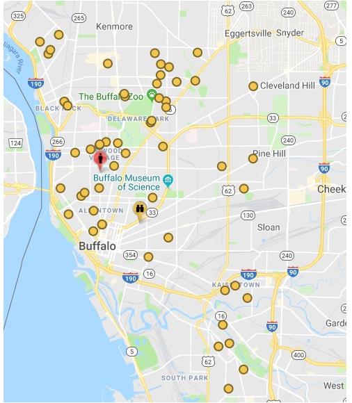
Project Report – Tree Planting Report, Buffalo, NY
Buffalo, NY i-Tree Planting Calculator Full Report
In the fall season (Oct 15-Dec 31) study of trees planted in Buffalo, NY in 2017, was completed and in late-spring 2019, a series of i-Tree studies were complete, including using the i-Tree Planting Calculator analysis. Using the i-Tree Planting Calculator, a calculation of the benefits gained from this planting effort was completed. With a projected lifespan of 50 years and tree mortality of 10%, these trees will intercept over 3 million gallons of rainfall and manage over 700,000 gallons of storm water at a cost savings of $6,640. Trees have the ability to pull greenhouse gasses (CO2) from the atmosphere and store it for long periods of time. 359,239 pounds of carbon dioxide will be sequestered with a cost savings of $8,354. Air pollutants removed by these trees include 1,200 pounds of ozone, 152 pounds of nitrogen dioxide, 75 pounds of sulfur dioxide, and 73 pounds of fine particulate matter. Through this planting effort the trees will save 26,099 kWh of electricity at a savings of $4,603. Additionally, 556 MMBtu of fuel will be saved at a cost savings of $8,824. In total this tree planting over 50 years will save the City of Buffalo $28,422.96.
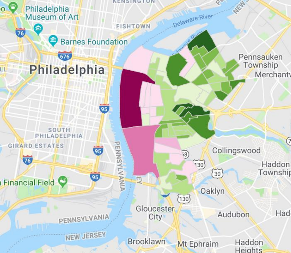
An i-Tree Canopy Analysis of the Logan Neighborhood, Spokane, WA
by Angel Spell
i-Tree Canopy Report – Logan Neighborhood
This project included completion of an i-Tree Canopy analysis and report for the Logan Neighborhood of Spokane, Washington. With i-Tree Canopy, you review Google Maps aerial photography at random points to conduct a cover assessment within a defined project area. This tool is designed to allow users to easily and accurately estimate tree and other cover classes (e.g., grass, building, roads, etc.) within their city or any area they like. This tool randomly lays points (number determined by the user) onto Google Earth imagery and the user then classifies what cover class each point falls upon. The user can define any cover classes that they like and the program will show estimation results throughout the interpretation process. Point data and results can be exported for use in other programs as well.
Initial recommendations for the use of i-Tree Applications in the update to the Community Forestry Mgt. Plan Guidelines – A Report to NJ Community Forestry Council Guidelines Subcommittee
by Levon Bigelow and Pam Zipse
The NJ Forest Service has a goal to encourage municipalities to utilize i-Tree to better understand the functions of the community forest. It is also considered important that the NJ Forest Service recommendations help to provide some standardization in the inventory structure that each participating municipality is utilizing in order to bring some level of uniformity to the program, and to enable meaningful comparisons of municipal tree resources throughout the State. This project represents the beginning steps toward refining a recommendation to include in the revision of the Community Forestry Management Plan Guidelines.
 Melody Park and Columbine Park Assessment – Boulder, CO
by Christy Spielman, GIS Analyst and Ellen Pesek, Assistant Forester
City of Boulder Parks and Recreation Department
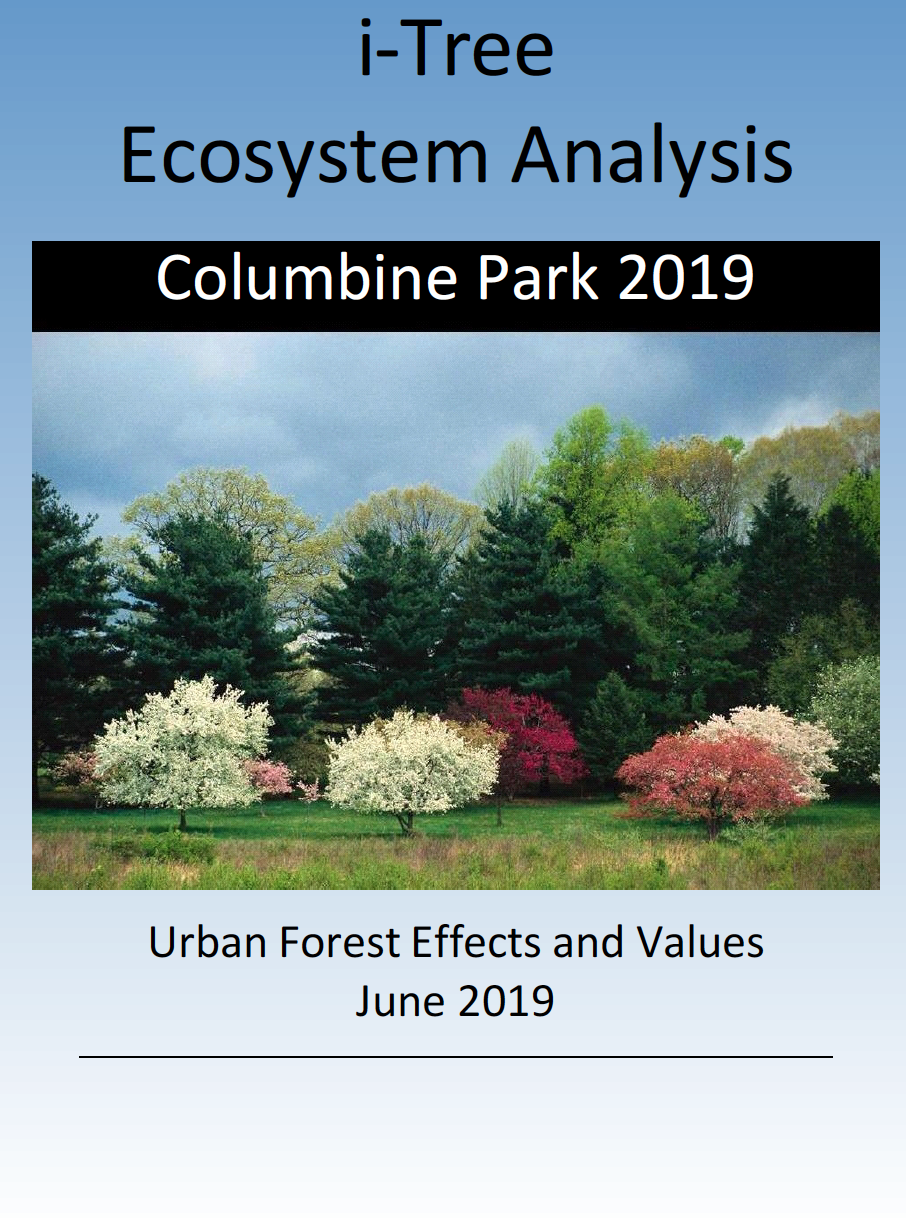
i-Tree Final Project Report: Melody Park and Columbine Park Assessment
Columbine Park i-Tree Eco Assessment
Melody Park i-Tree Eco Assessment
The City of Boulder, Colorado, is a lively community of over 107,000 people, attracting tourists from all over the world to visit well known destinations such as Chautauqua Park and the Flatirons. Tourists and residents also benefit from an additional 45 acres of City managed open space, over 150 miles of hiking trails, 60 maintained urban parks, and 51,000 inventoried public trees that provide them with numerous recreation activities. Essentially a green oasis in an otherwise high plains ecosystem along the Colorado Front Range Urban Corridor, Boulder’s residents not only rely on the green belt surrounding the city for recreation and solitude, but they also depend on their urban green spaces and trees within parks, medians, streets, and the public right of ways to reduce summer temperatures, sequester carbon and reduce urban heat island effects, mitigate storm water run-off, and to clean the air.
 i-Tree Design Report: Ruston, LA
by Darrell K. Street
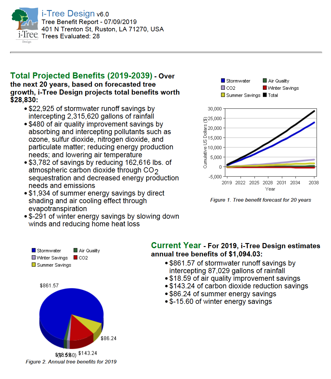
i-Tree Design Report for Ruston, LA
i-Tree Design allows anyone to make a simple estimation of the benefits provided by individual trees. With inputs of location, species, tree size, and condition, users will receive an understanding of tree benefits related to greenhouse gas mitigation, air quality improvements, and stormwater interception. With the additional step of drawing a building footprint – and virtually “planting” or placing a tree – tree effects on building energy use can be evaluated. Tree benefits are estimated for (a) the current year, (b) a user-specified forecast year sometime in the future, (c) the projected total benefits across that future timespan, and (d) the total benefits provided to date (based on estimated tree age). Multiple trees and buildings can be added to compare benefits or to provide a full accounting of a property’s trees. This report examines (28) trees in Ruston, LA using i-Tree Design.
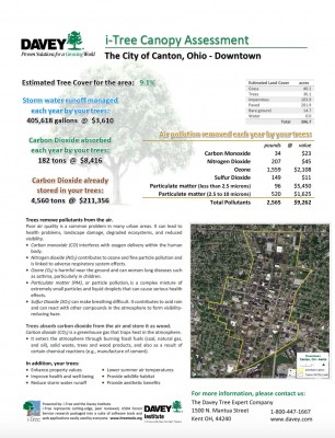 i-Tree Report Summary for Canton, OH (Downtown District)
by Emmanual Ong
Downtown Full Tree Report – Canton, OH
This assessment consists of an overall look at the tree benefits provided within the city of Canton, OH using i-Tree Landscape and then using i-Tree Canopy specifically for the downtown area. i?Tree Landscape gave the benefit estimates that the trees provide within city limits. i-Tree Canopy provided benefits in a specific area in order to connect this knowledge with the city arborists or any other interested parties of the benefits for their trees. Seeing these benefits furthers the idea that “more trees can add more benefits.”
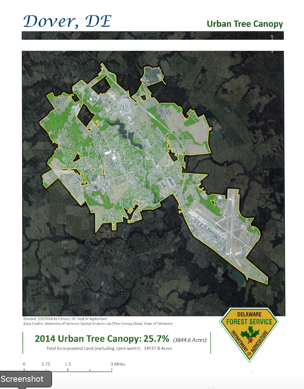
The City of Dover, DE Urban Tree Management Analysis
by Michael Martini
Full Analysis Report on Urban Trees in Dover, DE
The City of Dover currently has 25.7% urban tree canopy, which is 3844.6 acres out of the total 14937.8 acres included with the City of Dover limits. Dover has some of the oldest and largest historic trees in Delaware. The city contains the First State National Historic Park and 28 parks, which they are responsible for maintaining the trees along with all street tree plantings.
Using spatial data from the University of Vermont it is evident there are several locations within the City of Dover that have adequate space to plant or reforest.
 Greening the Gateway Cities – Springfield, MA: Trees for Energy and Public Health Benefits
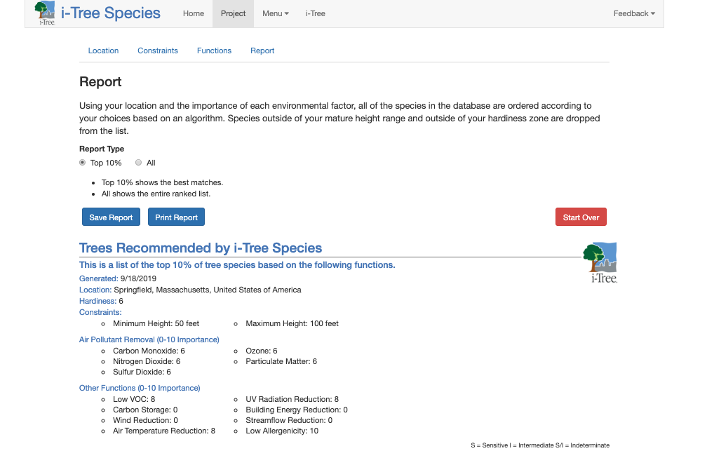
This project focuses on choosing the most appropriate trees to plant in Springfield, MA. To determine which trees are most appropriate to use, the main goal was to determine which trees would lower health risks for people living in the Springfield, MA community, of which about 16% of these residence have asthma. Springfield is a city that is located in the Western part of New England and is in the Hampden County.
The city sits along the Connecticut River and is one of the three largest cities in Massachusetts. Where there is dense communities and large populations often comes higher health risks. In order to determine which trees would be most beneficial to the community, trees were studied that were between 10- 30 feet, 30 – 50 feet and finally 50 -
100 feet using i-Tree

